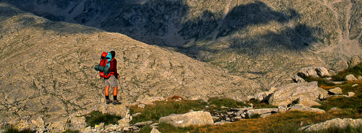
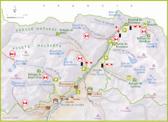
Benasque Valley is the central sector of the park, and includes the town of Benasque and Sahún. To access the park by this sector, we can do in four ways:
-
- Vado to Besurta Road:restricted access during peak periods. Public transport service.
- Vallibierna Road:restricted access during peak periods. Public transport service.
- Valle de Estós Road:restricted use. Authorized vehicles only throughout the year.
- Valle de Eriste Road:unrestricted and with a small parking area at the end of the runway for about 30 vehicles.
|
S-1 GEOMORPHOLOGIC PATH FORAU DE AIGUALLUTS |
|
| Walk type: |
lineal (Return the same way) |
| Distance: |
6.530m. (to reach) |
| Estimated time: |
1h. y 45 min (to reach) |
| Elevation: |
292m |
| Description: |
The path starts in the parking of the Vado of Besurta. All the way we are with blocks of granite that once carried the glacier. In just over 5 minutes to reach close to the Hospital de Benasque, we left on our right to continue the path that goes through pines and meadows to Plan d'Estan, prairie formed on an ancient lake. For a few hundred feet the path takes a logging road, passes by the cottage of Pllan d'Estan and returns to the meadow down to the Besurta. About 10 minutes after leaving the Besurta reached the crossing with the trail that goes up the right to the shelter of the Renclusa, so watch out to make the right direction, and that our path continues along the path of left which will lead directly to the lookout on the Forau de Aigualluts where we can enjoy the spectacular lanscape of the underground cavity whose roof has collapsed, and will have the opportunity to observe the Aneto glacier ending in a meadow where the river forms numerous meandering after a beautiful waterfall. |
|
S-3 ESTÓS VALLEY. IBONET DE BATISIELLES – IBÓN DE ESCARPINOSA |
|
|
Walk type: |
lineal (Return the same way) |
| Distance: |
5.800m. (to reach) |
| Estimated time: |
2h. y 30 min (to reach) |
| Elevation: |
717m |
| Description: |
The path starts in the car park early in the Estós Valley. The first part of the trail match with the path marked GR 11 (red and white markers). The route passes through Santa Ana's cabin and stay on the trail to find the exit for the Ibonet of Batisielles, we will find marked on the left. We left the wide track bottom of the valley and take the exit for the Ibonet, whose path ascends a lush beech forest until we find a tiny lake in an area of grassland, the Ibonet of Batisielles. To get to the end of our tour we continue to walk about 40 minutes, following the directional signs that lead us to a small path to the impressive Ibón of Escarpinosa. |
|
S-4 ERISTE VALLEY. ESPIGANTOSA WATERFALL – ÁNGEL ORÚS SHELTER |
|
|
Walk type: |
lineal (Return the same way) |
| Distance: |
3.100m. (to reach) |
| Estimated time: |
2h. (to reach) |
| Elevation: |
555m |
| Description: |
The trail starts in front of the waterfall Espigantosa. To access by car to the waterfall we take the asphalt road in the town of Eriste indicating access to the shelter Orús Angel (The Forcau). The trail zigzags up the slope to a point where the asphalt ends and the ground continues dirt and gravel. We will go through the viewpoint of Eriste, which should be on our left, and later find the crossing of the bridge Tamarrius also leave behind, as the track continues straight on to finish in the parking area in front of the waterfall Espigantosa. The tour matches with the PR-36 (yellow and white). The path stretches just across the bridge over the River Esera and ascends a lush riverside forest. After approximately 1 hour on the way we arrive at a more open area beside the river where we will find the bridge Presentet, good place to take a break before continuing the journey, from here presents a steep slope that is overcome by short loops of black pine area and rhododendrons, to reach the Angel Orus Shelter. |
|
S-5 LITEROLA VALLEY. IBONET DE BLANCO |
|
|
Walk type: |
lineal (Return the same way) |
| Distance: |
4.250m. (to reach)) |
| Estimated time: |
3h. y 15 min (to reach) |
| Elevation: |
872m |
| Description: |
We start from Benasque road to the valley after crossing the bridge over the ravine Lliterola, left out the path on a steep ascension between rocks and pines, which rises always parallel to the river. The trail continues along the shore until you reach the hut Lliterola shepherds (1 h. 30 'approximately), we leave to the left and continue ascending the terraces of grass to get to where the ravine narrowed is encased definitely and gives Ibonet of Lliterola step. |
|
S-6 SAHÚN. IBONES DE BARBARISA |
|
|
Walk type: |
lineal (Return the same way) |
| Distance: |
2.651m. (to reach) |
| Estimated time: |
3h. y 30 min (to reach) |
| Elevation: |
480m |
| Description: |
The trail begins in the town of Sahún, but can also be accessed from the hill halfway to Sahún. In the town of Sahún take the road to San Juan de Plan and Plan, also marked as PR-S1 (yellow and white) people running from the south and then get progressively and with a slight rise in the Valley of Sahún. The trail ascends the ravine Surri next to the course up to the cabin d'Es Prats, where we take the path back toward the ravine north of the mountain slope first left and then the right. |